A direct link to the above movie is at http://www.youtube.com/watch?v=7OR7meRm71w
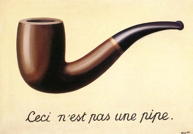 Image from wikipedia: René Magritte's famous painting, subtitled "This is not a pipe"
Chuck Salyers pointed me towards a fascinating wikipedia article on "The Map Territory Relation". Here's a few excerpts from the article, but please do read the whole thing:
The expression "the map is not the territory" first appeared in print in a paper that Alfred Korzybski gave at a meeting of the American Association for the Advancement of Science in New Orleans, Louisiana in 1931:Last blog, in "What's South of the South Pole?", we discussed the difficulty of envisioning things that are not part of the system we are within. With "the map and the territory", we have a way of thinking about how any representation of the system we are within is more useful if it finds ways to distill the elements, to avoid the uselessness of a map drawn to a scale of 1 to 1.
- A) A map may have a structure similar or dissimilar to the structure of the territory...
The Belgian surrealist artist René Magritte illustrated the concept of "perception always intercedes between reality and ourselves" in a number of paintings including a famous work entitled The Treachery Of Images, which consists of a drawing of a pipe with the caption, Ceci n'est pas une pipe ("This is not a pipe").
- B) A map is not the territory.
This concept occurs in the discussion of exoteric and esoteric religions. Exoteric concepts are concepts which can be fully conveyed using descriptors and language constructs, such as mathematics. Esoteric concepts are concepts which cannot be fully conveyed except by direct experience. For example, a person who has never tasted an apple will never fully understand through language what the taste of an apple is. Only through direct experience (eating an apple) can that experience be fully understood.
Lewis Carroll, in Sylvie and Bruno Concluded (1893), made the point humorously with his description of a fictional map that had "the scale of a mile to the mile." A character notes some practical difficulties with such a map and states that "we now use the country itself, as its own map, and I assure you it does nearly as well."
In a sort of counterpoint to Lewis Carroll, the University of Cambridge economist Joan Robinson (1962) emphasized the disutility of 1:1 maps and other overly detailed models: "A model which took account of all the variegation of reality would be of no more use than a map at the scale of one to one."
This is the power of the way of visualizing our reality as coming from ten dimensions as I've been portraying them - we have an intuitive way of encapsulating concepts that are much too big, much too all-encompassing, for us to be able to process without using representational maps. Which is not to say there is no value to the calculations physicists use to prove how our reality comes from the fifth dimension (as we explored in "The Holographic Universe"), or to deny the string theory idea that the potential for 10 to the power of 500 possible universes is contained within ten spatial dimensions (see "Does the Multiverse Really Exist?"): but rather, to return to the quote we've looked at before (in "Aren't There Really 11 Dimensions?") from physicist Michio Kaku:
In science, a physical picture is often more important than the mathematics used to describe it.As we've said before, in recent entries like Logic vs. Intuition, Computers and Consciousness, Do Shamans See Other Dimensions?, and Our Non-Local Universe: with Imagining the Tenth Dimension, we are using intuition to hold concepts in our mind that by all rights are really much too large to fit. Using Alfred Korzybski's analogy, we can say that's because this project is looking at an abstract representation: and looking at a map can be much more productive than looking at this unfathomably large territory that we're exploring.
- Michio Kaku, in his book Physics of the Impossible
Enjoy the journey,
Rob Bryanton
Next: Just Six Things: The I Ching


1 comment:
Hi rob, very interesting entry, it remided me of the map of london underground, do you know the story? it is a very interesting one:
http://homepage.ntlworld.com/clivebillson/tube/tube.html
And there is also a short story about one of my favourite autors, Borges, that I did not know but seems to be based on a Lewis story it is something like this:
The story elaborates on a conceit in Lewis Carroll's Sylvie and Bruno Concluded: a fictional map that had "the scale of a mile to the mile." One of Carroll's characters notes some practical difficulties with this map and states that "we now use the country itself, as its own map, and I assure you it does nearly as well."
The Borges story, credited falsely as a quotation from "Suarez Miranda, Viajes de varones prudentes, Libro IV, Cap. XLV, Lerida, 1658", imagines an empire where the science of cartography becomes so exact that only a map on the same scale as the empire itself will suffice. "[S]ucceeding Generations… came to judge a map of such Magnitude cumbersome... In the western Deserts, tattered Fragments of the Map are still to be found, Sheltering an occasional Beast or beggar..."
Hope it results interesting to you the information
Take care
M
Post a Comment